What is a Watershed Plan
A watershed management plan defines and addresses existing or future stormwater problems. It is a road map for reducing flood risk, improving water quality, assessing natural resource concerns, and outlines actionable steps that can be taken to address the concerns. Most planning efforts will establish partnerships, develop goals and objectives specific to their watershed, perform education and outreach, obtain stakeholder feedback, address financial obligations, and develop recommendations for implementation.
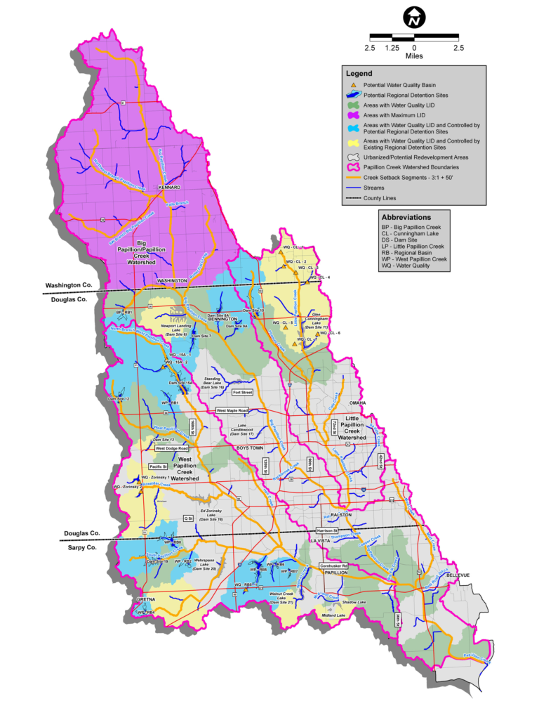
Papillion Creek Watershed Management Plan
The Papillion Creek Watershed Management Plan (Plan) was finalized in 2009 after extensive planning efforts from the PWCP since the formation of the partnership. The primary goals of the plan were to addresses both surface water quality and water quantity concerns within the Watershed.
The lakes and streams within the Watershed are monitored by the Nebraska Department of Environment and Energy. Regulatory listings of water quality impairments that have been experienced in waterbodies since 2009 include E.coli bacteria contamination in the streams, excessive nutrients and sediment accumulation in lakes, low oxygen levels, and isolated cases of toxic pollutants. The Plan developed recommendations for improving water quality that be incorporated on a local scale by developers and on a regional scale by the PWCP. These include:
- Water Quality Low Impact Development (WQ LID): implemented at the local level, WQ LID is a strategy designed to provide for water quality detention of the first ½ inch of stormwater runoff generated from each new development or significant redevelopment and to maintain the peak discharge rates during the 2- year storm event to baseline land use conditions. This can be achieved through several different best management practices, the most common being on-site detention basins located within a newly developed property.
- Water Quality Basins: implemented on a regional scale, water quality basins are in-stream impoundments that create receiving pool and wetland area designed specifically for sediment capture and nutrient reduction. They are essentially a dedicated stormwater pretreatment system when placed upstream of an existing or future reservoir intended to decrease sediment, nutrients, and other pollutants from being transported downstream. These are considered a structural Program Project that the PWCP would take the lead to implement.
The Watershed has a long history of flooding problems that have been studied and documented during the last 50+ years, and various plans for flood control and flood damage mitigation have evolved. Significant flooding threats from major storms still exist, and continued growth and re-development projects in the Watershed must implement appropriate surface runoff control measures to prevent increases in peak flow rates and, to the extent practicable, reduce peak flows and the threat of flooding. The Plan developed recommendations for peak flow management that be incorporated on a local scale by developers and on a regional scale by the PWCP. These include:
- Maximum Development (Max LID): implemented on-site within the development, Max LID is a strategy including detention designed not to exceed peak discharge rates of more than 0.2 cfs/acre during the 2-year storm event or 0.5 cfs/acre during the 100-year storm event based on the contributing drainage from each site, measured at every drainage (stormwater discharge) outlet.
- Regional Detention Basins: implemented on a regional scale, regional detention basins are large in-stream impoundments the provide flood attenuation of peak flow rates. These have been identified on main tributaries that control large drainage areas to maximize the level of flood reduction that is provided with each structure. The size and urbanized land use downstream classifies these has high hazards dams and each creates a reservoir of permanently impounded water. Recreation and habitat are additional benefits gained at these project sites. These are considered structural Program Projects that the PWCP would take the lead to implement; 15 were identified in the Plan.
The structural Program Projects are identified on the map and the current status can be viewed on the Projects page. The local scale practices implemented by developers are made a requirement through the PCWP Policies that have been adopted by all PCWP jurisdictions. The Plan also develops the financial framework for funding the projects and develops an implementation plan to guides the next steps for installation of the plan recommendations.
Plan Updates
It is the desire of the PCWP, every 5 years, to review the Watershed Management Plan and specifically update the plan components: 1) Financial framework 2) the Implementation Plan with respect to the availability of funds and rate of development within the Watershed. Plan updates were completed in 2014 and 2019, with the 2024 update currently underway.
Original Plan
View the original plan.